Archive preview (L1B thumb)
Product description
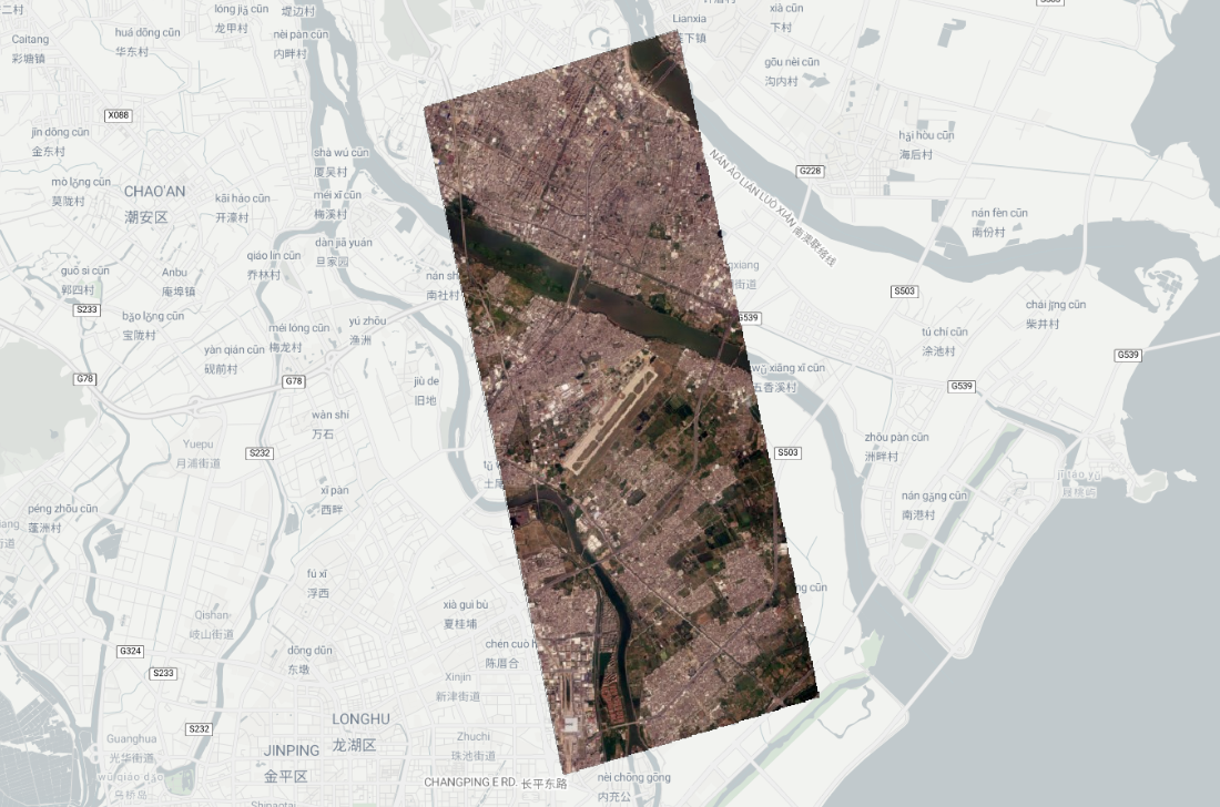
The Archive Preview product is a single, low resolution (20m pixel size) 4-band GeoTIFF mosaic built from all the L1 Basic (L1B) VISUAL tiles that compose a capture. Instead of exposing a capture as a collection of many small tiles, this product condenses the entire capture into one single raster, so that the whole outcome can be located, rendered and explored at a glance.
Because it covers a full capture in a single asset, it is published as one STAC item per capture, linked to its source capture through the satl:outcome_id property.
API only product
This product is not packaged for delivery to clients and cannot be ordered or downloaded as a standalone product. It is only accessible through the Archive STAC API, and exists to power catalog browsing experiences: it is the base collection used to populate and preview the archive, and is the imagery layer that Aleph uses to render captures when exploring the archive.
Technical characteristics
| Parameter | Value |
|---|---|
| Spectral bands | Red, Green, Blue, NIR |
| GSD | 20 m |
| Coverage | Full capture footprint, one item per capture (satl:outcome_id) |
| Image bit depth | 8-bit |
| Algorithms applied | Mosaicking and downsampling of L1B VISUAL tiles, reprojection to Web Mercator |
| Image format | GeoTiff, LZW lossless compression |
| Ancillary files | Cloud mask (GeoTiff), preview (PNG) and thumbnail (PNG). |
Projection
Unlike other processing levels, which are projected to UTM, this product is projected to Web Mercator (EPSG:3857) so that it can be readily consumed by web mapping clients, such as the one used in Aleph. The projection is indicated in the proj:epsg property of the item.
STAC item
Collection: quickview-visual-thumb
Assets
Note
Non documented files or parameters should be ignored.
All assets follow the same basename template.
{DATE}_{TIME}_SN{SATELLITE}_{PRODUCT_NAME}_{GSD}_{VERSION}_{SUFFIX}.{EXTENSION}
DATE: Year(4 digits)month(2 digits)day(2 digits)TIME: Hour(2 digits)minute(2 digits)second(2 digits)SATELLITE: Satellite numberPRODUCT_NAME: QUICKVIEW_VISUAL_THUMBNAILGSD: Ground sample distance of the mosaic, always 20mVERSION: The product version, with dots replaced by underscores, inherited from L1BSUFFIX: Depends on the assetEXTENSION: Depends on the asset type
All time values refer to the capture time in UTC. Hence the string 20261016_073809 represents actually 2026-10-16 07:38:09.
Raster
The analytic asset is an 8-bit, 4-band (Red, Green, Blue, NIR) GeoTIFF at 20m GSD, covering the full extent of the capture in a single file.
Cloud
The cloud mask is provided as a single band GeoTIFF. It is built by joining all the L1B tiles' cloud masks and resampling them to the same grid as the analytic asset.
Check here for details on how they are computed.
Preview and thumbnail
Downsampled versions of the analytic asset are included in .png format, as in every other processing level.
Metadata
Metadata is available per item, in STAC format. The following table shows the description of each field and an example corresponding to the sample item used throughout this page.
| Prefix | Field Name | Description | Example |
|---|---|---|---|
| n/a | id | Unique identifier for the STAC item. | 20261016_073809_SN47_QUICKVIEW_VISUAL_THUMBNAIL_20m_1_11_0_e7717778-8b3d-4e64-915a-a4e90b5da188 |
| n/a | bbox | Item bounding box. | [ 48.3663381549022, 30.6342862633218, 48.5581876632321, 30.8000402054266 ] |
| n/a | geometry | Footprint of the valid image data for the capture. | {
"type": "Polygon",
"coordinates": [[...]]
} |
| n/a | tile_geometry | Footprint of the full mosaic extent, including areas with no valid data (nodata). | {
"type": "Polygon",
"coordinates": [[...]]
} |
| n/a | collection | Collection name. | quickview-visual-thumb |
| n/a | assets | List of the assets available for the item. | {
"cloud": {...},
"preview": {...},
"analytic": {...},
"thumbnail": {...}
} |
| assets.analytic | eo:bands | The bands contained in the analytic raster. | [
{"name": "Red", "common_name": "red"},
{"name": "Green", "common_name": "green"},
{"name": "Blue", "common_name": "blue"},
{"name": "NIR", "common_name": "nir"}
] |
| properties | gsd | The ground sampling distance of the image, in meters. Always 20 for this product. | 20 |
| properties | datetime | Capture date and time. In UTC. | 2026-10-16T07:38:09.063549+00:00 |
| properties | platform | Satellite name that acquired the imagery. | newsat47 |
| properties | proj:epsg | The EPSG code of the projection. Always Web Mercator for this product. | 3857 |
| properties | proj:shape | Dimensions of the mosaic in pixels (Height x Width). Varies with the extent of the capture. | [900, 900] |
| properties | proj:transform | Affine transform mapping pixel coordinates to the projected CRS. | [20, 0, 247999.44, 0, -20, 3410000.38, 0, 0, 1] |
| properties | eo:cloud_cover | The percentage of cloud cover found on the image, from 0 to 100. In rare instances where cloud cover cannot be calculated, a sentinel value of 999 is assigned.a | 0 |
| properties | view:off_nadir | The off-nadir angle for the capture measured in degrees. | 38.2539 |
| properties | view:sun_azimuth | The azimuth angle of the sun at the target with respect to the north, in degrees. | 154.5554 |
| properties | view:sun_elevation | The elevation angle of the sun at the target at the moment of the capture, in degrees. | 48 |
| properties | satl:outcome_id | A unique identifier of the capture this item is built from. | e7717778-8b3d-4e64-915a-a4e90b5da188 |
| properties | satl:ground_lock | Indicates if there was enough GCP on the ground to geolocate the image. A false value indicates that the location of the image was done with onboard telemetry from the satellite and not a basemap. | true |
| properties | satl:valid_pixel | The percentage of valid pixels on the tile. If less than 100 it means that part of the image contains no data values.a | 89.6998 |
| properties | satl:haze_cover | The percentage of haze on the image, from 0 to 100 [experimental use]. In rare instances where cloud cover cannot be calculated, a sentinel value of 999 is assigned.a | 0.1329 |
| properties | satl:product_name | The unique name of the product. | QUICKVIEW_VISUAL_THUMBNAIL |
| properties | satl:product_version | The version of the product. Uses semantic versioning. Inherited from the product version of the corresponding L1B tiles. | 1.11.0 |
| properties | satl:satellite_generation | Satellite model category. | MarkV |
| properties | satl:transaction_id | Internal processing transaction identifier. | rr-to-stac-nkrvs |
| properties | satl:ba_[BAND]_response | The FFT phase correlation response between the [BAND] and the Green band. [BAND] can be Red, Blue, NIR. Typically a number >0.5 means there is good correlation between [BAND] and the Green band.a | 1.1415 |
| properties | satl:ba_[BAND]_radial | Radial error between the [BAND] band and the Green band, in pixels.a | 0.1272 |
| properties | satl:ba_[BAND]_xshift | X direction error between the [BAND] band and the Green band, in pixels. [BAND] can be Red, Blue, NIR.a | 0.0176 |
| properties | satl:ba_[BAND]_yshift | Y direction error between the [BAND] band and the Green band, in pixels. [BAND] can be Red, Blue, NIR.a | 0.0252 |
| properties | satl:geoaccuracy_[BAND]_radial | Radial error for the [BAND] band with respect to the basemap, in meters. [BAND] can be Red, Green, Blue, NIR.a | 2.2374 |
| properties | satl:geoaccuracy_[BAND]_xshift | X direction error between the [BAND] band with respect to the basemap, in meters. [BAND] can be Red, Green, Blue, NIR.a | -1.0252 |
| properties | satl:geoaccuracy_[BAND]_yshift | Y direction error between the [BAND] band with respect to the basemap, in meters. [BAND] can be Red, Green, Blue, NIR.a | -1.5654 |
| properties | satl:geoaccuracy_[BAND]_response | The FFT phase correlation response between the Green band and the [BAND]. [BAND] can be Red, Green, Blue, NIR. Typically a number >0.5 means there is good correlation between the basemap and the image being measured. For tiles with a value lower than that, the remaining geoaccuracy measurements are not relevant.a | 0.7518 |
\(^a\) This metric is an aggregation of this field across the set of L1B tiles that compose the capture.