Introduction
Introduction
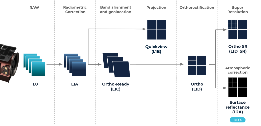
Satellogic offers data captured by our satellites in different imagery product formats. All products are generated from the raw data coming from the satellites, also known as L0 data. The following map provides a schematic view of how the different products are generated by using different processing algorithms:
The following list is an overview of the specifications and primary applications for each processing level. You can find all the details on the dedicated page of each product.
- Raw (L0): satellite sensor data, without any modifications to the pixel values. Intended for very advanced users who require the most pristine, unaltered instrument data.
- Raw corrected (L1A): maintains original sensor frame format but includes Top-of-Atmosphere (TOA) radiometric corrections and sensor artifact removal. Generally intended for advanced users who wish to apply their photogrammetry techniques from scratch.
- L1 Basic (L1B): radiometrically corrected and projected but not orthorectified imagery with fully coregistered bands, presented in fixed grid tiles. For rapid insights and detection.
- Ortho Ready (L1C): radiometrically corrected with fully coregistered bands data. It is designed for users who perform their own custom orthorectification using proprietary base maps, DEMs, or GCPs.
- Ortho (L1D) and Ortho Super-resolution (L1D_SR): radiometrically corrected, orthorectified, and projected imagery with coregistered bands, presented in fixed grid tiles with a standardized pixel size instead of native GSD. L1D-SR builds upon the L1D product by incorporating a super-resolution algorithm that enhances spatial detail. Designed for scientific and commercial applications requiring precise geometric alignment and enhanced detection capabilities.
- Surface reflectance (L2A): builds upon the L1D product with an additional atmospheric correction layer that converts the imagery from Top-of-Atmosphere (TOA) to Bottom-of-Atmosphere (BOA) surface reflectance. Recommended for accurate multi-temporal studies.
All products are available for Mark IV and V satellites families from their respective multispectral payloads.
Product versioning
All products adhere to Semantic versioning, meaning that:
Given a version number MAJOR.MINOR.PATCH,
- MAJOR version changes for incompatible API changes
- MINOR version changes for added functionality in a backward compatible manner
- PATCH version changes for backward compatible bug fixes