Ortho (L1D/L1D_SR)

Product description
The L1D and L1D_SR imagery products are 4-band (RGB+NIR) products designed for accuracy and best of class image quality. They are delivered to customers after going through a radiometric and geometric correction process.
The ortho products are currently offered in two major processing levels:
- L1D TOA Reflectance (L1D)
- L1D TOA Reflectance SuperResolution (L1D_SR)
L1D_TOA is a 4 bands (Blue, Green, Red and Near Infrared) imagery product with Top of the Atmosphere reflectance records measurements in physical units, and enables analysts to perform basic classifications and analytics. The imagery is radiometrically and geometrically corrected. Pixel values are scaled to TOA Reflectance (0 to 1) multiplied by a factor 10000 (1e4) to avoid float numbers. L1D TOA has a resolution of 1m for Mark IV and 0.7m for Mark V after resampling, which harmonises native pixel size that varies between 0.7m and 1.3m.
L1D_SR_TOA goes through one step further in processing which applies proprietary super resolution algorithm to improve the Ground Sample Distance (GSD) from 1m to 70 cm for Mark IV satellites and from 70cm to 50cm for Mark V satellites.
Both L1D and L1D_SR products are currently delivered along with a corresponding VISUAL Products called L1D_VISUAL and L1D_SR_VISUAL. This is a 3 bands imagery (red, green and blue) derived from the TOA product, processed with a color enhancement algorithm as described at section.
Both products are geometrically corrected using the GEDTM v1.2 as the vertical reference for orthorectification, providing accurate elevation data for accurate geometric correction.
The figure below illustrates the high level image processing workflow, which begins upon receiving raw data and is completed after the transfer of processed data to the image catalog and product delivery package:

For geometric and radiometric processing details please refer to Image processing section.
Technical Specifications
| Parameter | Mark IV |
Mark V |
|---|---|---|
| Spectral bands | Blue : 450 - 510 nm |
Blue : 450 - 517 nm |
| GSD | 1m (L1D) / 0.7m for (L1D_SR) |
0.7m (L1D) / 0.5m (L1D_SR) |
| Scene Swatha | 5.1 km |
6.5 km |
| Image bit depth | 8-bit for VISUAL, 16 bit for TOA |
|
| Max Off-Nadir angle | ± 25 deg |
|
| Algorithms applied | Radiometric correction, Band Alignment, Fine geolocation, Projection to UTM and orthorectification |
|
| Geolocation Accuracyb | 10m CE90 TBC |
|
| Band alignmentb | <= 2px CE90 TBC |
|
| Image format | GeoTiff, LZW lossless compression |
|
| Package Sizec | 9.5 MB/km² (L1D) |
19 MB/km² (L1D) |
| Ancillary files | Cloud mask (GeoTiff), preview (PNG), thumbnail (PNG), toa_factors (JSON) and imagery footprint in vector format. |
|
\(^a\) Varies with the altitude of the satellites and the off-nadir angle.
\(^b\) Nominal specifications include (but are not limited to) cloud-free conditions, high feature contrast, and nominal collection geometry.
\(^c\) Image size may vary depending on image content.
Packaging specification
The L1D package (the same applies for L1D_SR) is delivered as a package scene (via S3, FTP, or Zip download link) and contains the following files:
The following is the structure of the package directory (further details will be given in the corresponding subsections):
.
├── {date}_{time}_{second_decimals}_SN{sn}_{product_name}_{payload}_CLOUD.vrt
├── {date}_{time}_{second_decimals}_SN{sn}_{product_name}_{payload}_footprint.kml
├── {date}_{time}_{second_decimals}_SN{sn}_{product_name}_{payload}_metadata_iso.xml
├── {date}_{time}_{second_decimals}_SN{sn}_{product_name}_{payload}_metadata_stac.geojson
├── {date}_{time}_{second_decimals}_SN{sn}_{product_name}_{payload}_preview.png
├── {date}_{time}_{second_decimals}_SN{sn}_{product_name}_{payload}_solar_and_viewing_angles.geojson
├── {date}_{time}_{second_decimals}_SN{sn}_{product_name}_{payload}_thumbnail.png
├── {date}_{time}_{second_decimals}_SN{sn}_{product_name}_{payload}_toa_factors.geojson
├── {date}_{time}_{second_decimals}_SN{sn}_{product_name}_{payload}_TOA.vrt
├── {date}_{time}_{second_decimals}_SN{sn}_{product_name}_{payload}_TOA.vrt.ovr
├── {date}_{time}_{second_decimals}_SN{sn}_{product_name}_{payload}_VISUAL.vrt
├── {date}_{time}_{second_decimals}_SN{sn}_{product_name}_{payload}_VISUAL.vrt.ovr
└── rasters
    ├── {date}_{time}_{second_decimals}_SN{sn}_{product_name}_{payload}_CLOUD_{chunk_index}.tif
    ├── {date}_{time}_{second_decimals}_SN{sn}_{product_name}_{payload}_TOA_{chunk_index}.tif
    └── {date}_{time}_{second_decimals}_SN{sn}_{product_name}_{payload}_VISUAL_{chunk_index}.tif
Note
Non documented files or parameters should be ignored.
All assets follow the same basename template.
{DATE}_{TIME}_{SECOND_DECIMALS}_{SATELLITE}_{PRODUCT}_{PAYLOAD}_{SUFFIX}.{EXTENSION}
DATE: Year(4 digits)month(2 digits)day(2 digits)TIME: Hour(2 digits)minute(2 digits)second(2 digits)SECOND_DECIMALS: All the decimal part from the timestamp secondsSATELLITE: Satellite numberPRODUCT: L1D / L1D_SRPAYLOAD: MS for multispectral (4 bands)SUFFIX: depends on the assetEXTENSION: depends on the asset type
All time values refer to the capture time in UTC. Hence the string 20220619_153346_938 represents actually 2022-06-19 15:33:46.938.
Rasters and previews
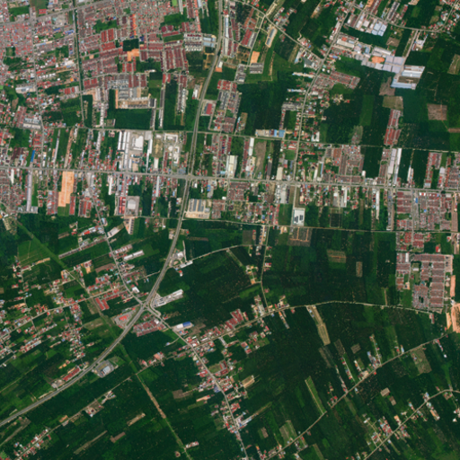
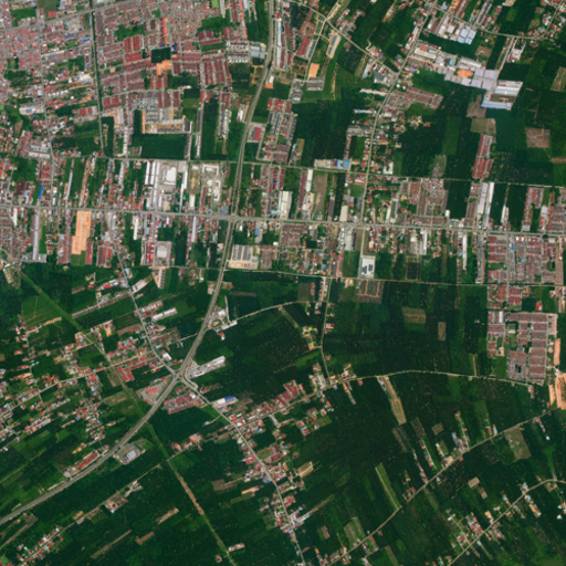
We provide the TOA raster as a .vrt file (together with the corresponding .vrt.ovr overview). An 8bits, RGB enhanced version of the original BGRN raster with the same spatial resolution is also delivered as VISUAL. Downsampled versions (preview and thumbnail) are also provided for visualization purposes in .png format.
The corresponding GeoTiff files that together compound the .vrt are located inside the rasters directory. Scene delivery is conditional on the geographical extent of its bounding box, with a threshold of 100 kilometers established for the longest side.
- Delivery in a single chunk: if the longest dimension of the scene's extent is less than 100 kilometers, the entire scene is presented in a single image file. In the previous table nomenclature, there will be only one chunk N=0. In particular, all standard POIs we offer (25, 50 and 100 square kilometers) are delivered in this manner.
- Chunking via fixed grid: if the longest dimension exceeds the 100 km threshold, the scene is subjected to tiling based on a fixed, predefined grid system.
- Hierarchical grid: this system is derived from base $2 \times 2 \text{ km}$ cells (tiles grid), which are aggregated into larger delivery tiles of $80 \times 80 \text{ km}$ (resulting from $40 \times 40$ base cell groups).
- Non-constant segment size: consequently, the size and shape of the resulting output chunks are not constant. The final size of each chunk is determined by how the scene's extent intersects with the boundaries of this fixed $80 \times 80 \text{ km}$ delivery grid.
- Captures whose geographical extent straddles the boundary between two or more UTM zones may contain chunks that do not conform to the standard format described above. Generally, these chunks have dimensions significantly smaller than expected due to fragmentation in the transition zones of the projection.

Products are projected to the corresponding coordinate reference system (CRS) according to their closest matching UTM Zone. The projection is indicated in the proj:epsg property of each product metadata. If a scene is captured across different zones, the entire scene is projected to the zone with more data.
Cloud mask
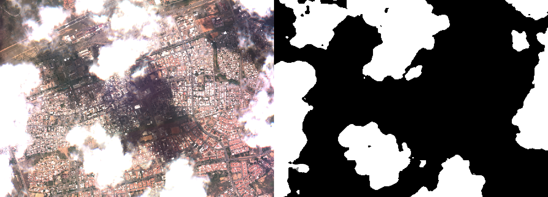
A cloud mask is also provided as single band GeoTIFF (also in .vrt format and .tiff within the rasters directory). Check here for details and how masks are computed for L1D product.
For L1D_SR, the cloud masks are inherited from the corresponding L1D product and upscaled with a nearest neighbour strategy to the target resolution.
Footprint
{date}_{time}_{second_decimals}_SN{sn}_{product_name}_{payload}_footprint.kml contains the product footprint in Keyhole Markup Language.
Toa Factors
The L1D/L1D_SR product raster is provided in Top Of Atmosphere (TOA) reflectance units (which take values between zero and one), encoded with a 10000 factor in order to fit them in a standard Tiff file. The radiometric conversion factors are inherited from the input images (L1C) processing level.
| Properties | Example |
|---|---|
| toa_to_radiance_units | W / (m^2 . nm . sr) |
| toa_reflectance_to_radiance | {
"blue": 4.776162676561445,
"green": 4.844255590869656,
"nir": 13.011088418320432,
"red": 4.919852418190033
}, |
| reflectance_scale_factor | {
"blue": 0.0001,
"green": 0.0001,
"nir": 0.0001,
"red": 0.0001
} |
Solar and viewing angles
{date}_{time}_{second_decimals}_SN{sn}_{product_name}_{payload}_solar_and_viewing_angles.geojson file contains the tiled information related to the satellite viewing angles, altitude and solar angles.
| Properties | Example |
|---|---|
| satellite viewing angles | {
"azimuth": 88.659999999999997,
"off_nadir": 14.56,
“incidence_angle”: 16,
"units": "degrees"
} |
| solar angles | {
"azimuth": 98.519999999999996,
"elevation": 54.619999999999997,
“zenith”: 46,
"units": "degrees"
} |
| satellite altitude | {
"units": "meters",
"values": 407043.03
} |
Metadata files
Included in the deliverable package we have different metadata files.
STAC Metadata in Geojson format
{date}_{time}_{second_decimals}_SN{sn}_{product_name}_{payload}_metadata_stac.geojson
This files describes the main attributes of the capture in Geojson format. In particular, it contains STAC Common Metadata and it is summarized in the following table:
| Geometry attribute | Description | Example |
|---|---|---|
| gsd | Ground sample distance in meters | 0.5 |
| created | Deliverable creation date | 2025-09-01T20:04:56.442757Z |
| platform | Satellite name that acquired the imagery | newsat46 |
| datetime | Capture time | 2025-09-06T18:43:23.402269+00:00 |
| platform | Satellite name | NewSat |
| proj:epsg | EPSG code of the Coordinate Reference System in which the image coordinates are | 4326 |
| providers | Imagery acquisition responsible | [
{
"url": "https://satellogic.com/",
"name": "Satellogic",
"roles": [
"producer",
"processor"
],
"description": "High-resolution geospatial imagery and analytics"
}
] |
| instruments | Options are multispectral and hyperspectral | multispectral |
| satl : outcome_id | The UUID of the entire capture this individual frame is part of | ffbabb4f-3a97-45ec-bca3-0e4d56608c1c |
| satl : exposure_sec | Exposure time of capture in seconds | 0.002769 |
| satl : product_name | The product name | L1D_SR |
| satl : product_version | Product Version | 1.4.0 |
| satl : satellite_generation | Satellite generation category, mainly to differentiate between MarkIV and MarkV | MarkV |
| eo : cloud_cover | Percentage of the image covered by clouds | 6.37 |
| constellation | Satellite constellation | Aleph1 |
| view : azimuth | Viewing azimuth angle. The angle measured from the sub-satellite point (point on the ground below the platform) between the scene center and true north. Measured clockwise from north in degrees (0-360) | 166.1138 |
| view : off_nadir | The angle from the sensor between nadir (straight down) and the scene center. Measured in degrees (0-90). In case this angle cannot be computed, a value of -1 will be reported | 24.9490 |
| view : sun_azimuth | Sun azimuth angle. From the scene center point on the ground, this is the angle between true north and the sun. Measured clockwise in degrees (0-360) | 72.3332 |
| view : sun_elevation | The estimated sun elevation measured at the target at the moment of the capture. Value in degrees. | 60 |
ISO 19115-2 Metadata
{date}_{time}_{second_decimals}_SN{sn}_{product_name}_{payload}_metadata_iso.xml
Satellogic adheres to industry standards governing metadata schemas that align with ISO standards. The adoption of ISO 19115 (ISO metadata standard) ensures that information about sensor identification, image extent, quality, spatial and temporal aspects, content, spatial references, distributions, and other properties of digital geographic data are provided in a XML format for customers seeking to integrate Satellogic map-ready orthorectified raster data directly into their workflows.
The table below shows the metadata fields according to ISO 19115-2:
| Identifier | Type | Description |
|---|---|---|
| gmd:fileIdentifier | string | Unique file identifier |
| gmd:language | code | Language used for metadata (eng) |
| gmd:characterSet | code | Character coding standard in the metadata (utf8) |
| gmd:contact | string | Contact information of the company responsible for the metadata information (Satellogic) |
| gmd:dateStamp | date | Date of dataset creation in UTC |
| gmd:metadataStandardName | string | Name of the metadata standard used (ISO) |
| gmd:metadataStandardVersion | string | ISO metadata standard version |
| Spatial representation information: grid spatial representation | ||
| gmd:numberOfDimensions | integer | Number of independent spatial-temporal axes (2d: x, y ) |
| gmd:axisDimensionProperties | string/integer | Dimension name (column) and size (integer), resolution (m) |
| gmd:cellGeometry | code | Grid data identification (area) |
| gmd:transformationParameterAvailability | boolean | Dataset coordinates and geographic or map coordinates availability |
| gmd:referenceSystemInfo | string/date | Information of CRS provider, release date, version and edition details |
| Metadata extension information | ||
| gmd:MD_ExtendedElementInformation | string | Exposure time (seconds) and responsible party information (Satellogic) |
| Data identification | ||
| gmd:Citation_title | string | Name of the dataset |
| gmd:Citation_Date | date | date in UTC |
| gmd:abstract | string | Scene set identification (Scene set ID) |
| gmd:pointOfContact | string | Contact information |
| gmd:resourceMaintenance | string | Information on dataset maintenance |
| gmd:resourceConstraints | string | The limitations or constraints on the use of or access to dataset |
| gmd:spatialRepresentationType | code | Object used to represent the geographic information |
| gmd:language | code | Languages of the dataset using standard ISO three letter codes (eng) |
| gmd:characterSet | code | Character coding standard in the dataset |
| gmd:environmentDescription | string | Describes the dataset's processing environment |
| gmd:extent | decimal | Information about geographic extent of the dataset (bounding box coordinates) |
| gmd:supplementalInformation | string | Satellogic constellation, satellite name and satellite generation |
| Content info | ||
| gmd:attributeDescription | string | Sensor type |
| gmd:contentType | string | Dataset content type |
| gmd:dimension | string | Imagery bands information (name and wavelength) |
| gmd:illuminationElevationAngle | decimal | Sun elevation angle in degrees |
| gmd:illuminationAzimuthAngle | decimal | Sun azimuth angle in degrees |
| gmd:imageQualityCode | string/date | Metadata standard and version release |
| gmd:cloudCoverPercentage | decimal | Percentage of the area covered by clouds |
| gmd:processingLevelCode | string | Corresponds to data product level |
| gmd:compressionGenerationQuantity | integer | Compression information |
| Distribution info | ||
| gmd:distributionFormat | string | Dataset format name and version |
Digital signature
Additionally, every L1D and L1D_SR package includes a digital signature to ensure data authenticity and integrity. Each package contains a manifest file and cryptographic signature that allows verification that the delivered data has not been tampered with. Learn more about Digital Signature verification.
Known issues
This section lists imagery product anomalies which sometimes slip through the automatic quality assurance filters due different reasons, appearing clearly different from images that have gone through imagery quality assurance pipeline. The most known anomalies are explained in this section.
Flipped pixel values in RGB enhanced images
The current image enhancement algorithm causes some flipped pixel values in saturated areas. This will be corrected in future versions of the pipeline.

Reduced geo-accuracy
Some terrain types and environmental conditions might cause the Ground Control Points (GCPs)-based geometric correction to fail, producing captures of lower geo-accuracy. Standard imagery products are delivered with less than 10m geoaccuracy, however, because of high terrain and the lack of GCPs, especially in areas without human made structures such as water, deserts, forests etc., less than 10m geoaccuracy is not achievable, hence some delivered images might show a shift in geolocation. In some extreme cases, such as over open water, such products are marked as a low geoaccuracy quality tier and not generally delivered to customers, but are available on demand for customers who do not have strict geoaccuracy requirements. Some examples are provided below.

Digital Elevation Model (DEM) distortions
Orthorectified images can present distortions in the presence of outliers in the DEM used during imagery processing. Satellogic is able to detect these problems in the DEM and use alternative models. Occasionally the detector may fail to locate the outliers and produce geometric distortions that affect terrain features.
These elevation errors can cause linear features—such as roads, rivers, or building edges—to appear warped or distorted, particularly in challenging terrain. The severity of this issue tends to be more pronounced in mountainous regions and areas characterized by steep terrain slopes, as well as in coastal zones adjacent to sea level.
The images below illustrate this effect: the first shows general distortion in high-altitude, steep terrain areas. The second and third examples compare the same area before and after correction, showing how linear features that should remain straight can become warped due to DEM outliers, and how an improved elevation models can restore geometric rigidity.

| With DEM Outliers (Warped Linear Features) | With Improved DEM (Proper Geometric Rigidity) |
|---|---|

|

|
| Linear features (roads) appear warped and distorted due to DEM outliers. | With an improved DEM, the proper geometric rigidity of linear features is recovered. |
Discontinuities
Discontinuities may also be inherited from L1C processing level
Frame loss during satellite data transmission
Missing frames may also be inherited from L1C processing level
Changelog
Changelog L1D
| Version | Release date | Change log |
|---|---|---|
| 2.4.0 | 13/07/2026 |
|
| 2.3.0 | 01/07/2026 |
|
| 2.2.0 | 04/02/2026 |
|
| 2.0.1 | 19/11/2025 |
|
| 2.0.0 | 17/11/2025 |
|
| 1.2.0 | 12/06/2025 |
Before: Item ids differed only for tile grid number 20250612_075918_430_SN46_L1D_MS_38N_456_4852_1_1_220250612_075918_430_SN46_L1D_MS_38N_472_4848_1_1_2After: Item ids also differ for <TIME>20250617_094442_485_SN28_L1D_MS_42N_740_3616_1_2_020250617_094445_023_SN28_L1D_MS_42N_736_3596_1_2_0 |
| 1.1.2 | 19/12/2024 |
|
| 1.1.1 | 07/11/2024 |
|
| 1.1.0 | 06/11/2024 |
|
| 1.0.1 | 14/10/2024 |
|
| 1.0.0 | 01/10/2024 |
|
| 0.3.0 | 12/07/2024 |
Changed
|
| 0.2.0 | 29/04/2024 |
Fixed
|
| 0.1.0 | 03/04/2024 |
Added
|
Changelog L1D_SR
| Version | Release date | Change log |
|---|---|---|
| 2.0.1 | 26/11/2025 |
|
| 2.0.0 | 17/11/2025 |
|
| 1.4.0 | 21/08/2025 |
|
| 1.4.0 | 11/06/2025 |
|
| 1.3.0 | 04/06/2025 |
|
| 1.1.2 | 19/12/2024 |
|
Imagery End User Rights Agreement and Terms of Use
All imagery products are delivered under Satellogic Imagery End User License Agreement. The terms and conditions of the agreement are available to customers and accessible online on the website under License Agreement.