Introduction
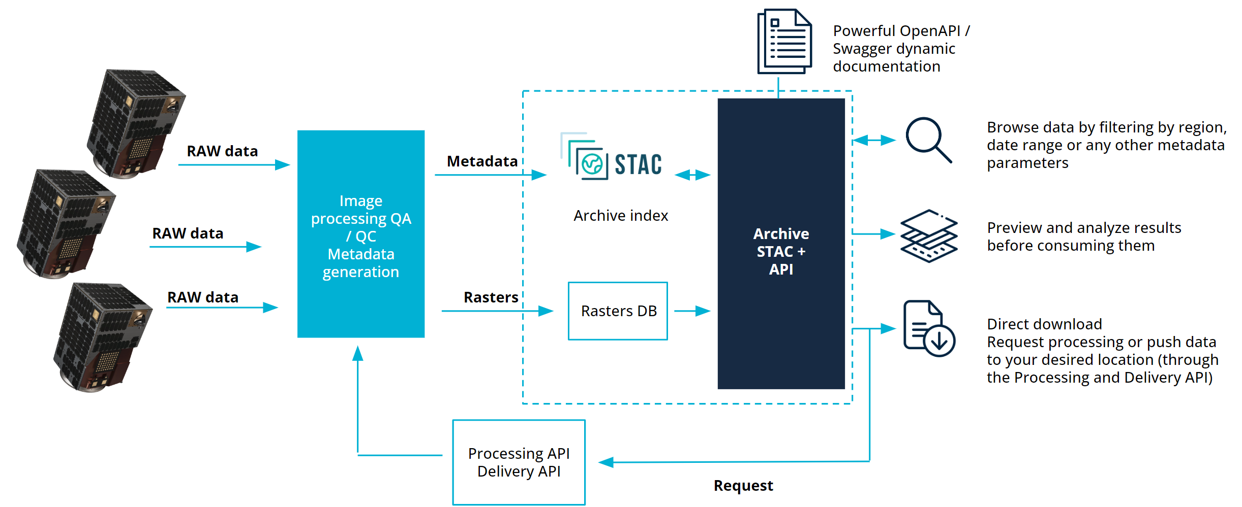
The archive API can be used to browse, filter, preview, analyze and consume Satellogic's imagery. It's a combination of a STAC API, and data storage.


Raw data coming from the satellites is processed by different processors to generate different processing levels and their associated metadata. This data is stored in our databases and indexed into a catalog for browsing historical records available in the Archive. From there, users can browse, filter and consume the data.
This archive catalog is implemented using STAC standard format and implements full compliant STAC-API. Then, users can use any STAC compatible tool to browse the catalog and consume the data they need from our storage.
Archive content
The Aleph Archive contains all imagery that has been downlinked and processed. Every capture includes a default L1 Basic (L1B). This is a visual, geolocated preview that enables rapid inspection of the scene. L1B is designed for speed and consistency—it is not orthorectified but remains spatially referenced and optimized for browsing, even in the presence of clouds or challenging terrain. L1 Basic has two subproducts: the VISUAL and the TOA, click here to learn more.
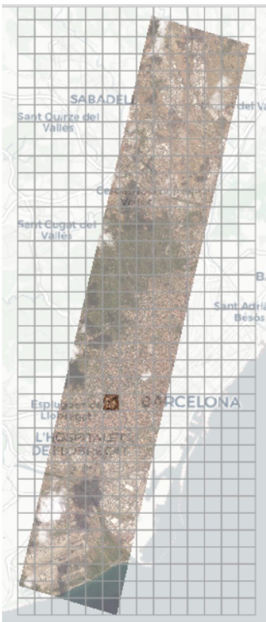
This processing level is generated for every scene captured by our satellites and it also contains historical data currently beign ingested. The scenes are tiled into a 2km by 2km grid in order to be ingested into the archive. There's one STAC item in this collection for each of the tiles generated.

Traceability
Each tile includes metadata that ensures full traceability back to the satellite and the specific capture event. In Aleph, a capture is uniquely identified by an outcome_id. This identifier is available in each tile's metadata under the key satl:outcome_id. By using this value, users can retrieve all tiles associated with the same capture, making it easy to locate adjacent or related imagery when needed.
Capture chunking and overlapping areas
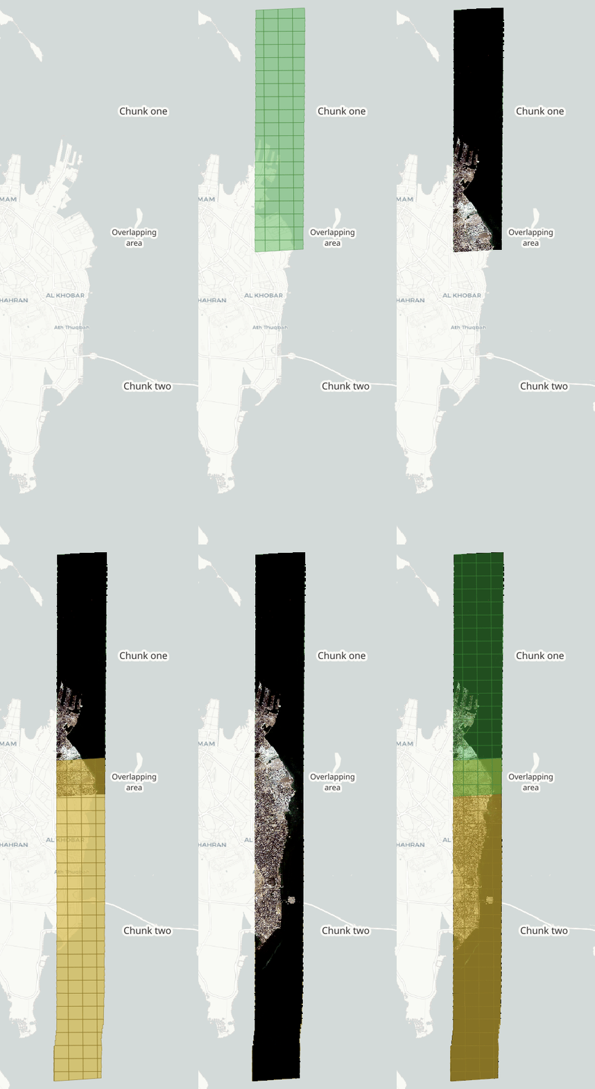
To keep processing scalable and efficient for large captures, the image processors implement a "chunking" strategy that automatically splits stripes longer than a threshold into smaller, overlapping chunks.
Process Details and Data Duplication
This chunking approach deliberately creates data redundancy in the archive. When the processed output is tiled into the 2km x 2km grid, data that falls within the overlapping regions of the chunks results in duplicate STAC items for that single grid section.
To prevent data overwrite in the catalog, the IDs of these overlapping tiles are explicitly differentiated by a millisecond timestamp. This duplication impacts our tiled processing levels: L1B, L1D, and L1D_SR.
The images below display a scene chunking, overlapping area and tiles grid.
| Complete stripe | Chunk one | Chunk two | Both chunks | Chunking |
|---|---|---|---|---|

|

|

|

|

|
Data Resolution and Consumption
This internal redundancy will not affect platform deliverables. The system automatically generates a single, seamless mosaic crop for any order, internally resolving the duplication before delivery.
However, Archive API users consuming the raw tiled data should employ a filtering strategy to manage the overlap:
- Identify Duplicates: Duplicated tiles can be identified as they share the same value in the
grid:codefield. - Select Preferred Tile: To select the optimal tile from a duplicated pair, you may choose the one with the larger value in the
satl:valid_pixelfield.
Request processing
If a capture exists in the archive but is not yet available at the desired processing level, users can: - Use the WEB to request higher-level processing on demand. - Contact their Account Manager for support.

Collection Reference
The Archive is organized into STAC collections, and access depends on your organization’s permissions. Available collections correspond to the processing levels defined in the Imagery Product Specification and may vary depending on your contract.
| Processing Level | STAC Collection Name |
|---|---|
| RAW (L0) | l0 |
| Raw Corrected (L1A) | l1a |
| L1 Basic (L1B) | quickview-visual, quickview-toa |
| Ortho Ready (L1C) | l1c |
| Ortho (L1D) | l1d |
| Ortho Super Resolution (L1D_SR) | l1d-sr |
Note: Not all processing levels are available for every capture. Use the L1 Basic processing level as the entry point to explore and assess imagery before requesting additional processing.