QuickView (L1 Basic)
Product description
The QuickView (L1 Basic) product is a 4-band (RGB and Near infrared) product designed for fast very low latency processing time that can be generated from Mark IV and Mark V satellites raw imagery. It is geolocated and projected to the ground but not orthorectified. This imagery product is currently used in Rapid Response products, as well as the base collection to browse the archive. It's produced in native resolution, hence having a varying GSD depending on Satellite's altitude and off-nadir angle.
Technical characteristics
| Parameter | Mark IV |
Mark V |
|
|---|---|---|---|
| Spectral bands | Blue : 450 - 510 nm |
Blue : 450 - 517 nm |
|
| GSD | 0.7m - 1.35m 1 |
0.73m - 0.81 1 | |
| Scene Swath | 4.8 - 5.5 Km 1 |
6.8Km - 8.5Km 1 | |
| Image bit depth | 8-bit for VISUAL, 16 bit for TOA |
| |
| Max Off-Nadir angle | ± 25 deg |
| |
| Algorithms applied | Radiometric correction, Band Aligment, Geolocation, Projection to UTM |
| |
| Geolocation Accuracy | <= 30m TBC CE90 2 |
| |
| Band aligment | <= 2px TBC |
| |
| Image format | GeoTiff, LZW loseless compression |
| |
| Ancilliary files | Cloud and usable data mask (GeoTiff), preview (PNG) and thumbnail (PNG). |
| |
Product presentation
QuickView has two subproducts, a VISUAL and a radiometrically corrected, top-of-atmosphere, TOA version. On it's VISUAL version, the output is an 8-bit geotiff and has a streched histogram that enhanced the visibility of the capture for exploration purpouses. The TOA version has a radiometrically corrected 16-bit in units of reflectance and included in the metadata there are coeficcients to convert reflectance into radiance.
 The QuickView product can be consumed in two presentation or packaging options. As a full scene, or as tiles. A scene is a single image as it was captured by one of Satellogic's satellites.
Tiles are a more granular version of the same scene, that can be used for more granular exploration and consumption.
Scenes are typically used when users requiere the entire capture that has been tasked using the Tasking API and can also be requested on demand from data found on the archive.
Currently, QuickView scenes are only available for Tasking orders and delivered to pre-configured AWS S3 bucket. It will become available for download from the API directly. Tiles are found on the Archive STAC API under the quickview-visual and quickview-toa collections.
The QuickView product can be consumed in two presentation or packaging options. As a full scene, or as tiles. A scene is a single image as it was captured by one of Satellogic's satellites.
Tiles are a more granular version of the same scene, that can be used for more granular exploration and consumption.
Scenes are typically used when users requiere the entire capture that has been tasked using the Tasking API and can also be requested on demand from data found on the archive.
Currently, QuickView scenes are only available for Tasking orders and delivered to pre-configured AWS S3 bucket. It will become available for download from the API directly. Tiles are found on the Archive STAC API under the quickview-visual and quickview-toa collections.
Projection
This imagery product is projected in UTM, to the corresponding projection parameters according to their closest matching UTM Zone. The projection is indicated in the proj:epsg property of each tile or in the metadata files of each scene. If a scene is captured across different zones, the entire scene and corresponding tiles are projected to the zone with more data.
Product components
Each QuickView imagery product, in both tiles and scene presentations have multiple elements associated with them as well as the corresponding metadata.
Raster, preview and thumbanil

The full resolution raster as well as downsampled versions for preview and thumbnails.
Cloud and usable data mask
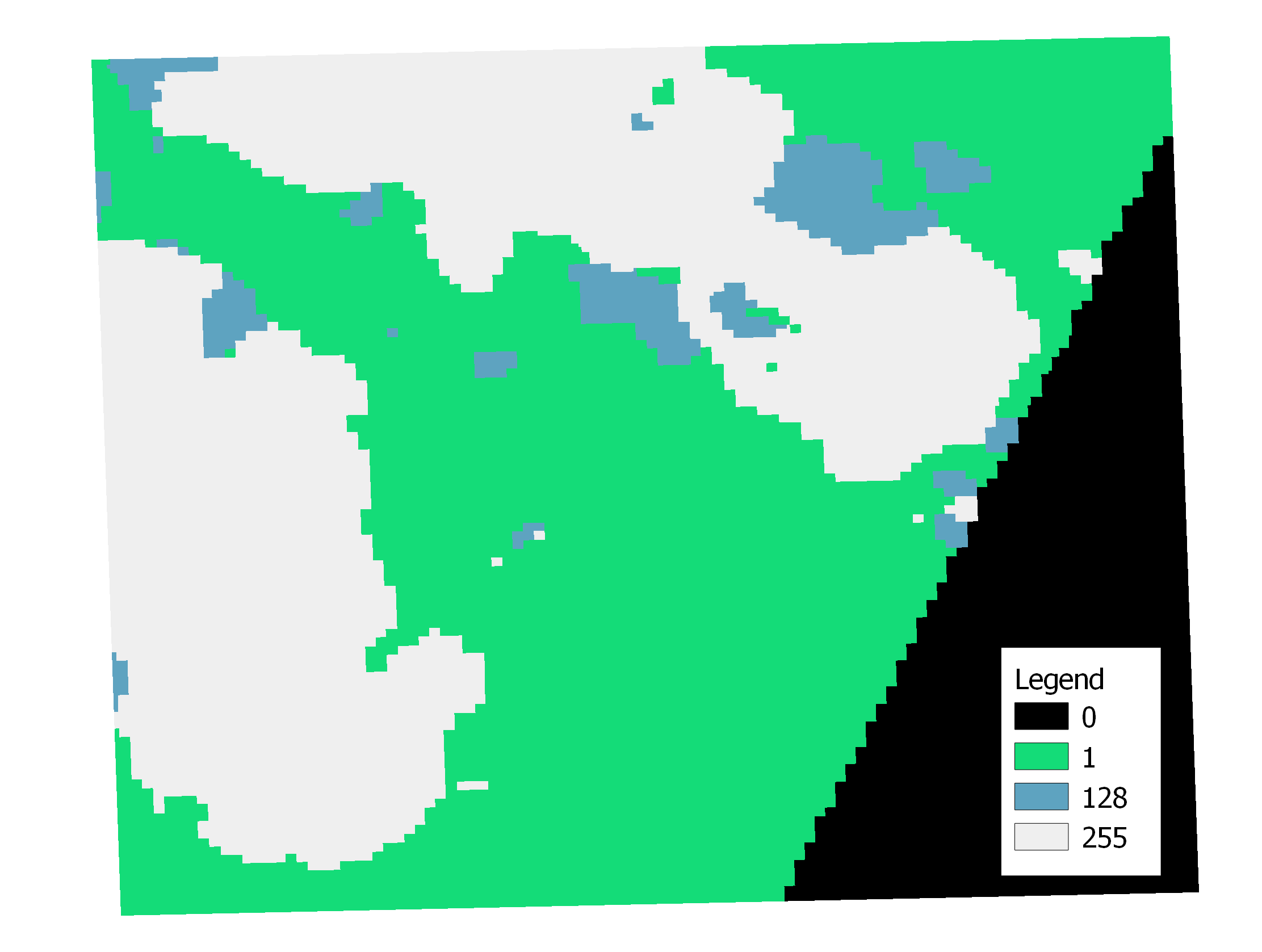 The mask is a single band GeoTiff. The values of the raster represent different cloud data as follows:
- 0: nodata
- 1: valid_data
- 128: shadow_data
- 255: cloud
Metadata
Metadata is available for the entire scene in STAC and ISO format, and per tile in STAC format. Common metadata can be found across tiles of the same capture. In tiles, the metadata corresponds to the information of that tile. For scenes, some metadata is aggregated.
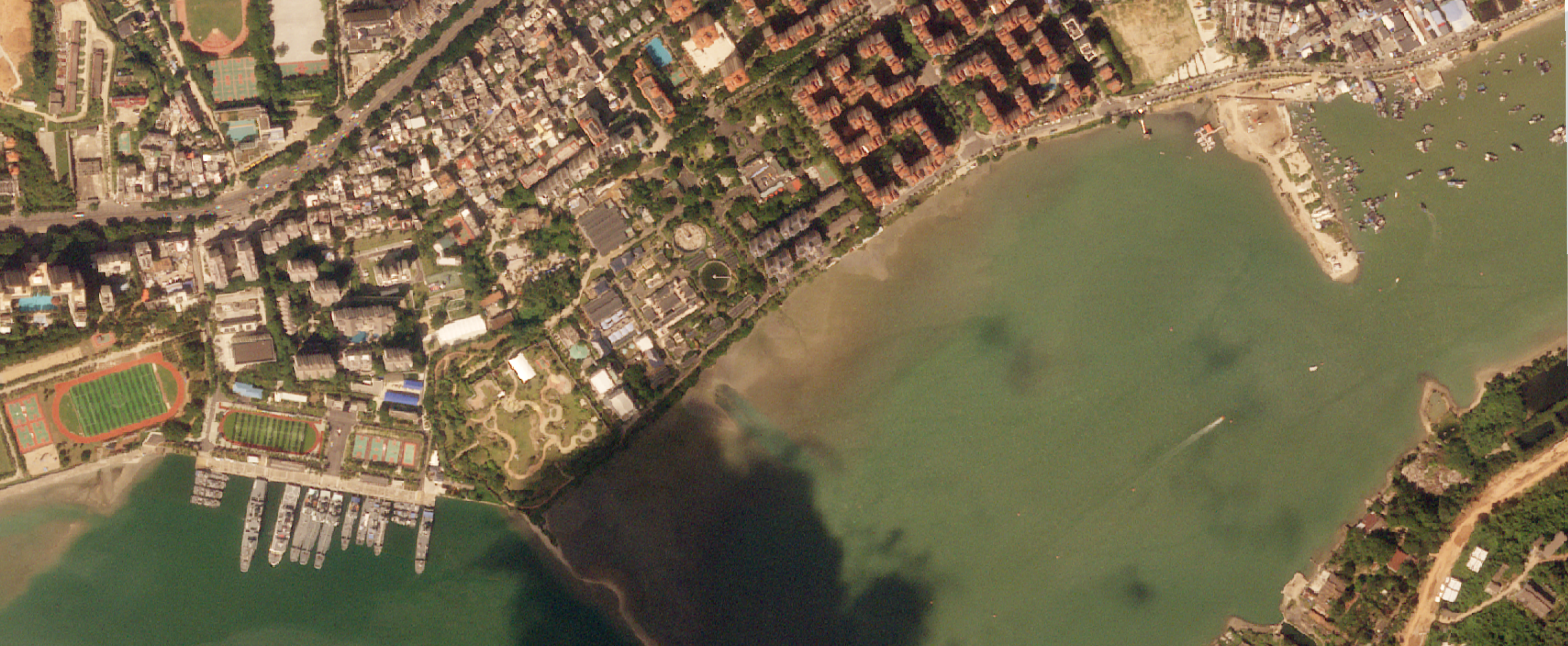
The following table shows the description of each field and an example corresponding to the capture used in previous section.
| Field | Description | Example |
|---|---|---|
| gsd | The ground sampling distance of the image, in meters. | 0.78 |
| datetime | Capture date and time of the tile. In UTC | 2023-09-22T02:29:17.823169536+00:00 |
| platform | Satellite name that acquired the imagery | newsat13 |
| grid:code | Satellogic 2km grid code for this tile. See below | SATL-2KM-52N_137_2088 |
| proj:epsg | The EPSG projection used corresponding to the UTM zone. See below | 32652 |
| eo:cloud_cover | The percentage of cloud found on the image, from 0 to 100. | 41.7 |
| view:off_nadir | The off-nadir angle for the capture measured in degrees. | 25.8465 |
| view:sun_elevation | The elevation angle of the sun at the target, at the moment of the capture, in degrees. | 50.4441 |
| view:sun_azimuth | The azimuth angle of the sun at the target the with respect to the north | 156.912 |
| satl:outcome_id | A unique identifier of the associated capture with this tile. | d5627157-d1aa-472d-9daa-a55086fd32c2--161551 |
| satl:ground_lock | Indicates if there was enough GCP on the ground to geolocate the image. A false indicates that the location of the image was done with onboard telemetry from the satellite and not a basemap. | True |
| satl:valid_pixel | The percentage of valid pixels on the tile. If less than 100 it means that part of the image contains NO_DATA | 81.533 |
| satl:shadow_cover | The percentage of shadows, probably due to clouds found on the image, from 0 to 100 [experimental use]. | 4.9 |
| satl:product_name | The unique name of the product of which this tile corresponds to | QUICKVIEW_VISUAL |
| satl:product_version | The version of the product. Uses semantic versioning. | 1.1.0 |
| satl:ba_[BAND]_response | The FFT phase correlation response between the [BAND] band and the [BAND] from the basemap. [BAND] can be Red, Green, Blue. NIR is not evaluated, since that band is usually not present in most basemaps. Typically a number >0.5 means there is good correlation between the basemap and the image being measured. For tiles with a value lower than that, the remaining geoaccuracy measuremnents are not relevant. | 0.785 |
| satl:ba_[BAND]_radial | Radial error between the [BAND] band and the Green band, in pixels | 0.057 |
| satl:ba_[BAND]_xshift | X direction error between the [BAND] band and the Green band, in pixels. [BAND] can be Red, Blue, NIR. | -0.004 |
| satl:ba_[BAND]_yshift | Y direction error between the [BAND] band and the Green band, in pixels. [BAND] can be Red, Blue, NIR. | -0.057 |
| satl:geoaccuracy_[BAND]_radial | Radial error for the [BAND] band with respect to the basemap, in meters. [BAND] can be Red, Green, Blue, NIR. | 9.289 |
| satl:geoaccuracy_[BAND]_xshift | X direction error between the [BAND] band with respect to the basemap, in meters. [BAND] can be Red, Green, Blue, NIR. | 8.13 |
| satl:geoaccuracy_[BAND]_yshift | Y direction error between the [BAND] band with respect to the basemap, in meters. [BAND] can be Red, Green, Blue, NIR. | 4.495 |
| satl:geoaccuracy_[BAND]_response | The FFT phase correlation response between the Green band and the [BAND]. [BAND] can be Red, Green, Blue, NIR. Typically a number >0.5 means there is good correlation between the basemap and the image being measured. For tiles with a value lower than that, the remaining geoaccuracy measuremnents are not relevant. | 0.764 |
| satl:uint16_to_reflectance_[BAND] | The scale to apply to the DN value of every pixel to obtain reflecantes units between 0 and 1 . [BAND] can be Red, Green, Blue, NIR. Only available for TOA versions of the product. It has a fixed value | 0.0001 |
| satl:uint16_to_radiance_[BAND] | The scale to apply to the DN value of every pixel to obtain radiance units of W/(m² sr nm) . [BAND] can be Red, Green, Blue, NIR. Only available for TOA versions of the product. | 0.0005934402 |
Packaging specification
All the components of the product are included and/or mapped into the two different packacing options, as tiles or as scenes following their corresponding support format.
Tiles
 The QuickView tiles are available on the Archive STAC API. Each STAC item is a 2km by 2km square tile.
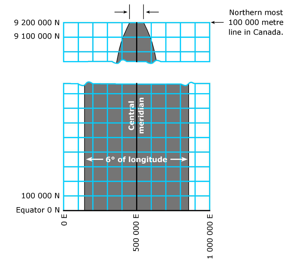
They are aligned to a fixed discrete grid, aligned to the prime meridian of each UTM zone (coordinate 500000m). Each tile has a designated grid code included in the property grid:code as follows:
The QuickView tiles are available on the Archive STAC API. Each STAC item is a 2km by 2km square tile.
They are aligned to a fixed discrete grid, aligned to the prime meridian of each UTM zone (coordinate 500000m). Each tile has a designated grid code included in the property grid:code as follows:
SATL-<GRID SIZE>-<UTM ZONE> _ <X> _ <Y>
Where X and Y correspond to the easting and northing coordinates of the bottom left corner of the tile.
For example the grid:code SATL-2KM-10N_298_2062 should be interpreted as: - SATL grid of 2km by 2km - On UTM zone 10N - With the left bottom corner at 298,000m easting and 2062,000m northing.
Each item/tile contains the following assets/components:
| STAC Item asset name | Component |
|---|---|
| analytic | The full resolution raster corresponding to the tile |
| preview | A 128x128 pixels PNG preview of the raster |
| thumbnail | A 64 x 64 pixels PNG thubmnail of the raster. |
| cloud | The Geotiff cloudmask as defined above. |
Scenes
Scenes are delivered as a single folder. The file name follow the following format:
<DATE>_<TIME>_SN<SATELLITE_NUMBER>, for example like 20231114_222725_SN22. It contains both the VISUAL and TOA versions of the product.
Inside each package, each file has the prefix <DATE>_<TIME>_SN<SATELLITE_NUMBER>_RR_<SUBPRODUCT>_MS. Where <SUBPRODUCT> can be either VISUAL or TOA.
The following files and folders can be found in a typical scene:
.
├── <DATE>_<TIME>_SN<SATELLITE_NUMBER>_RR_VISUAL_MS.vrt
├── <DATE>_<TIME>_SN<SATELLITE_NUMBER>_RR_VISUAL_MS_footprint.kml
├── <DATE>_<TIME>_SN<SATELLITE_NUMBER>_RR_VISUAL_MS_iso.xml
├── <DATE>_<TIME>_SN<SATELLITE_NUMBER>_RR_VISUAL_MS_metadata_stac.geojson
├── <DATE>_<TIME>_SN<SATELLITE_NUMBER>_RR_VISUAL_MS_preview.png
├── <DATE>_<TIME>_SN<SATELLITE_NUMBER>_RR_VISUAL_MS_thumbnail.png
├── <DATE>_<TIME>_SN<SATELLITE_NUMBER>_RR_TOA_MS.vrt
├── <DATE>_<TIME>_SN<SATELLITE_NUMBER>_RR_TOA_MS_footprint.kml
├── <DATE>_<TIME>_SN<SATELLITE_NUMBER>_RR_TOA_MS_iso.xml
├── <DATE>_<TIME>_SN<SATELLITE_NUMBER>_RR_TOA_MS_metadata_stac.geojson
├── <DATE>_<TIME>_SN<SATELLITE_NUMBER>_RR_TOA_MS_preview.png
├── <DATE>_<TIME>_SN<SATELLITE_NUMBER>_RR_TOA_MS_thumbnail.png
├── <DATE>_<TIME>_SN<SATELLITE_NUMBER>_RR_TOA_MS_toa_factors.geojson
└── rasters
    ├── <DATE>_<TIME>_SN<SATELLITE_NUMBER>_RR_VISUAL_MS_<N>.tif
    └── <DATE>_<TIME>_SN<SATELLITE_NUMBER>_RR_TOA_MS_<N>.tif
| File | Description |
|---|---|
| *.vrt | A GDAL Virtual raster that contains all the corresponding TIFs in the rasters folder. In case of very big images, mutliple tifs can be included in the package. |
| *_footprint.kml | The overal raster ground footprint in KML |
| *_metadata_iso.xml | A Metadata file in ISO 19115-2 format containing the key information from the metadata of the product. See the metada section for more information. |
| *_metadata_stac.geojson | A Metadata file in STAC format containing the aggregated information of the product. See the metada section for more information. |
| *_preview.png | The preview component of the product for the entire scene |
| *_thumbnail.png | A low resolution thumbnail of the scene |
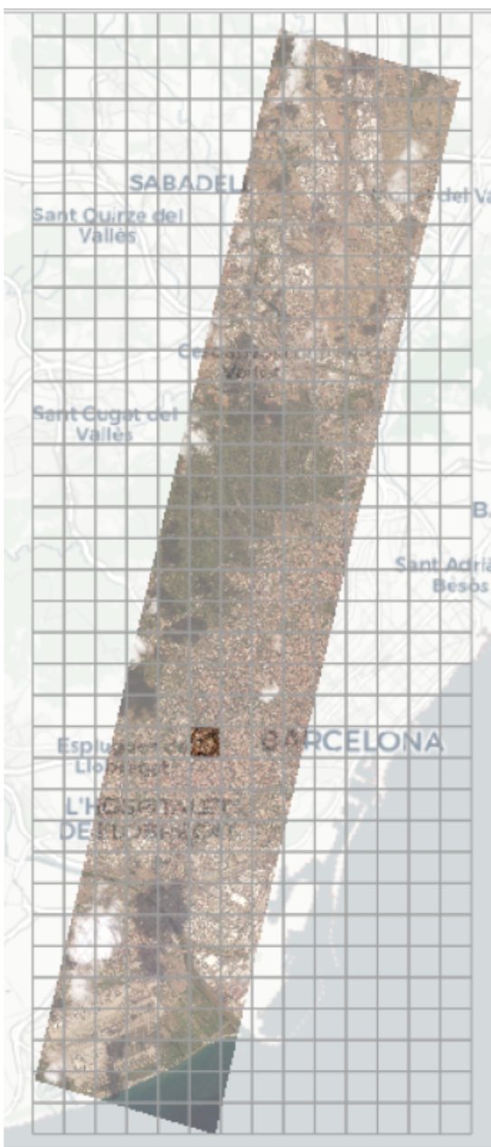
| *_toa_factors.geojson | A Geojson file that contains the coefficients to transform the TOA product into Radiance units. |
| rasters/*_ |
The full resolution raster that comprises the full scene. For very large captures, the rasters are divided into smaller chinks. The number |
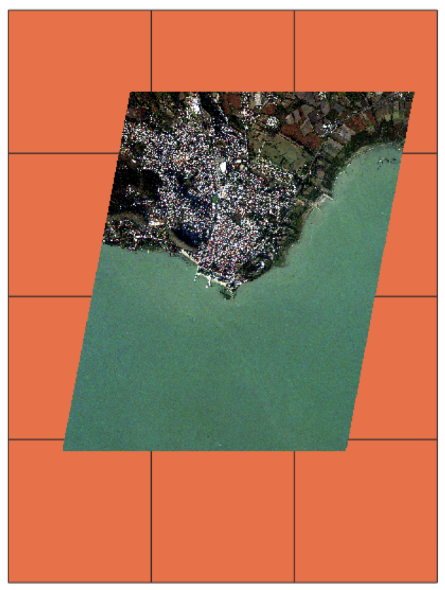
The *_toa_factors.geojson file contains the coefficients for converting the DNs into Radiance and Reflectance units respectively as a geojson tiled filed. The image on the right depicts this file overlaid with the raster file for reference. Small variation of the radiance coefficients can be expected across the image.
Known issues for current version v1.2.0
- The cloud and usable data mask is not included in the Scenes format of the Quickview imagery product.
Changelog
[v1.2.0] 2023-02-29
- Improved ratio of locked ground images
- TOA conversion factors (uint16_to_radiance) metadata is now corrected.
- From this version, the Off-nadir is computed from satellite POV instead of observation POV (the elevation angle)
- Fixed extra_samples metadata removing warnings when opening files
[v1.1.10] 2023-11-27
- Toa thumbs fixed
- Less brightness image on Visual Product
[v1.1.9] 2023-11-16
- MarkV Orirentations should be fixed
[v1.1.8] 2023-11-16
- Geolocation improvements
- Over-water band alignment improved
[v1.1.7] 2023-11-13
- bug fixes
- ability to start from L1A products
[v1.1.6] 2023-11-03
- Internal improvements, no change in imagery product.
[v1.1.5] 2023-11-03
- Band alignment improvements on saturated areas
[v1.1.4] 2023-10-31
- Internal improvements, no change in imagery product.
[v1.1.3] 2023-10-27
- Improved thumbnail quality
[v1.1.2] 2023-10-25
- Fixed counterclockwise exterior ring in metadata footprint [Warning: breaking change!]
- Improved saturation mask for cloud detector
[v1.1.1] 2023-10-24
- Improved imagery sharpnes
- Fixed tile ID to reflect the real position of the tile.
[v1.1.0] 2023-10-19
- Improved visual product for consistency among very long captures
- Tiling size to 2km
- Changed production naming from RR to QUICKVIEW
- Previews encoded in png now include alpha channel
[v1.0.0] 2023-09-18
- Initial release